What a Naples Topographic Survey Reveals About Your Lot
Explore Our Services
Contact Us Today!
(239) 322-9295
A Naples topographic survey maps the shape and visible features of a building lot, including elevations, contours, swales, trees, and existing structures. It gives your design team a picture of how the land sits before a home, addition, or pool changes it.
That picture matters because a flat-looking Southwest Florida lot can still have subtle grade changes that affect drainage and construction costs . Here's how to read the survey and use it when planning your project.
What a Topographic Survey Records
A topographic survey shows the existing physical conditions within its agreed scope. A Florida-licensed surveyor measures locations and elevations in the field, then presents the information on a drawing.
Natural and Built Features
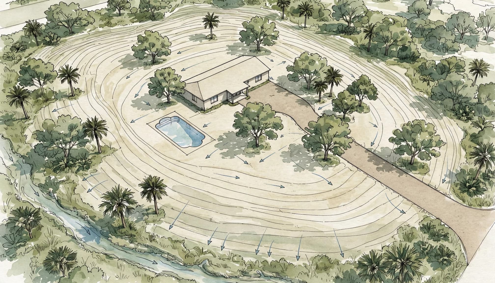
Depending on the assignment, the drawing may locate trees, visible drainage swales, ditches, canals, and changes in the ground surface. It can also show features such as a house, driveway, sidewalk, fence, seawall, or drainage inlet.
These details help the design team see what is already on the lot and what may affect construction. For example, an existing driveway or mature tree can influence where equipment enters the property.
Survey Scope Shapes the Drawing
A topographic survey is a record of the features the surveyor was asked and able to locate. Dense vegetation, debris, parked equipment, or standing water can limit access to parts of the site.
The drawing also reflects conditions when the fieldwork took place. If someone brings in fill, removes a structure, or regrades the yard afterward, the earlier survey may no longer describe the surface the builder will encounter.
How Elevations and Contours Describe the Land
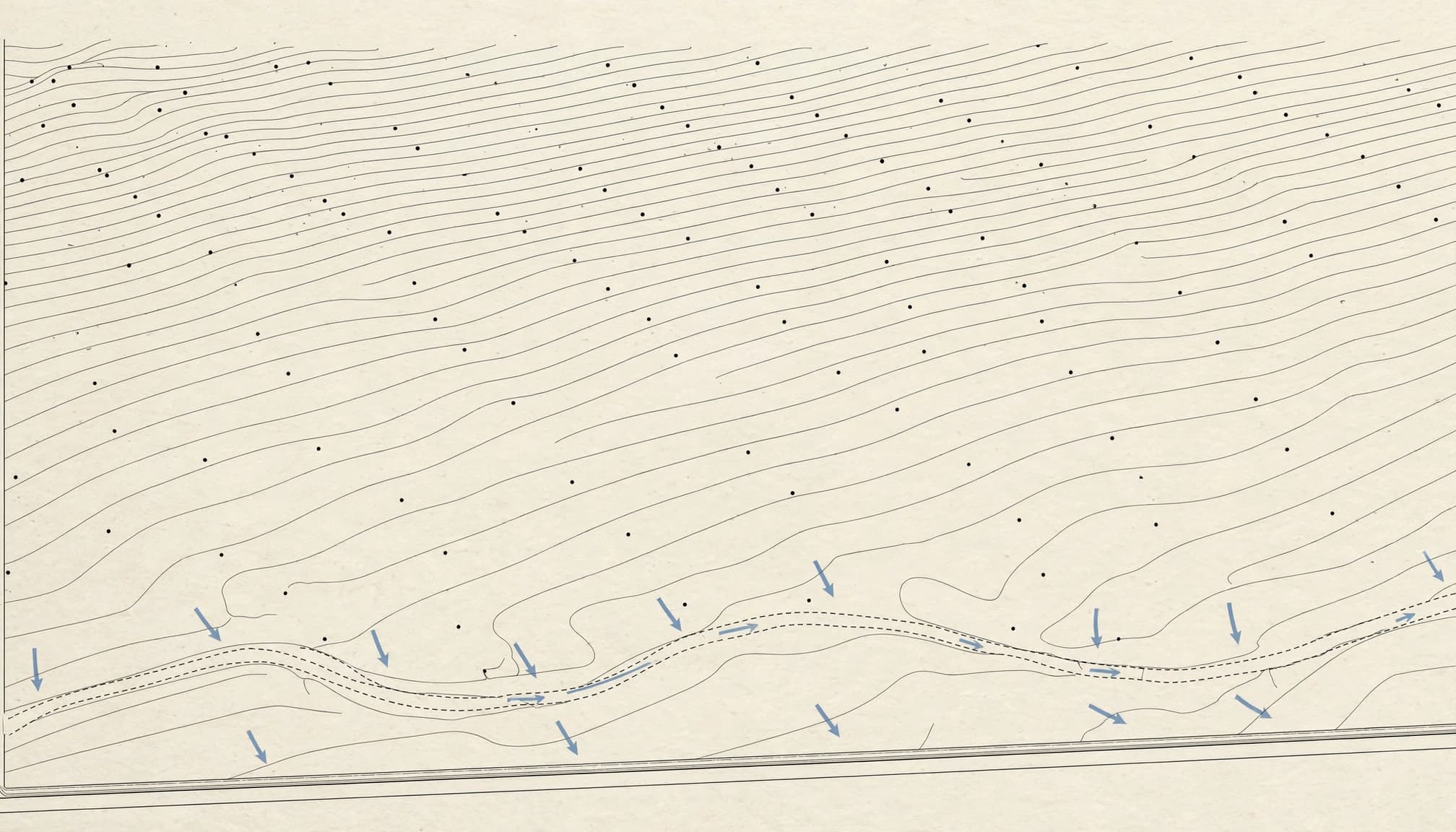
Elevations tell you the height of measured points relative to a stated vertical reference, or datum. They may appear as numbers at individual spots, while contour lines connect points of equal elevation.
Reading Spot Elevations
Spot elevations can document the ground near a doorway, the edge of a driveway, the bottom of a swale, or another important location. Designers compare those points with the proposed floor, patio, and driveway elevations.
The datum matters when comparing drawings. Elevation numbers on different documents need a consistent reference before the team can use them together. The survey's benchmark and datum information help establish that common reference.
Reading Contour Lines
Contours make the shape of the ground easier to see across a larger area. Lines close together generally indicate a steeper slope; lines farther apart indicate a gentler slope.
On a relatively flat lot, individual spot elevations can be especially useful. A small difference across a long yard may be hard to see on a walk-through, yet it can affect the route available for runoff.
The drawing's contour interval also affects how much detail the lines convey. Contours describe the measured surface, but they don't show every small dip or obstruction between measured points.
What the Survey Reveals About Drainage
A topographic survey helps a designer trace where surface water may travel by showing high and low points, swales, and nearby drainage features. It provides the starting surface for a drainage plan.
Existing Flow Paths
Water generally moves downhill, so the relationship between elevations matters. A shallow swale along a side yard may carry water toward the street or another drainage feature. A low area beside an existing home may also deserve attention before an addition or patio covers it.
Survey elevations alone don't show the full behavior of water during a storm. Downspout locations, paved surfaces, drain capacity, and conditions beyond the surveyed area can all affect where runoff collects.
Proposed Changes to Runoff
A house, driveway, pool deck, or raised garden wall can interrupt an existing flow path. The design team can use the survey to develop proposed grades that move water away from structures and avoid redirecting it onto neighboring property.
Our guide to planning pool grading and drainage explains how a pool layout, deck, and drainage route fit together.
A survey shows existing ground conditions. A grading and drainage plan shows the intended changes after construction.
Topographic Survey vs. Boundary Survey
A topographic survey and a boundary survey answer different questions. Many building projects benefit from having both types of information, sometimes combined in one drawing.
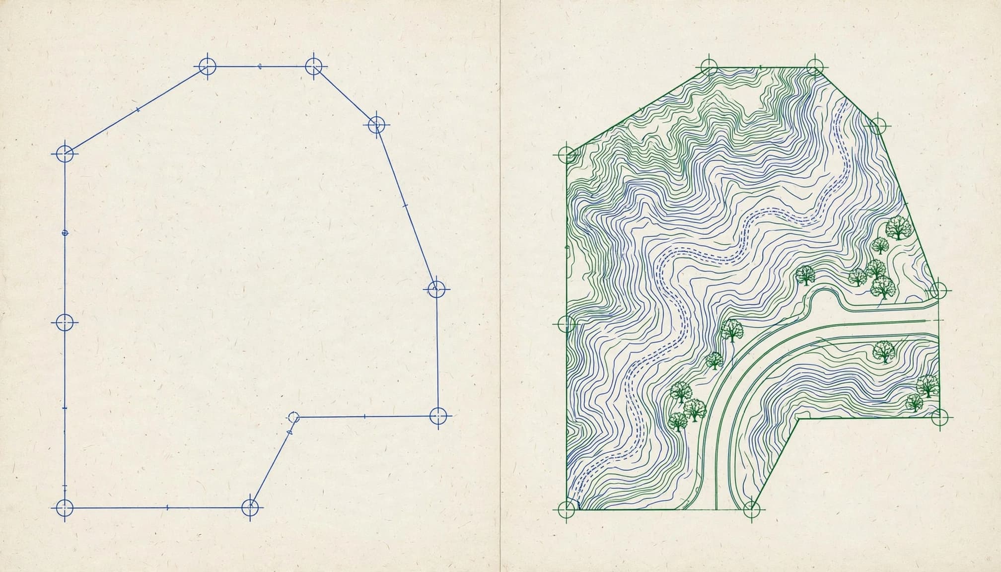
Here's the practical distinction:
| Survey | Main purpose | Information it can provide |
|---|---|---|
| Boundary survey | Establish the property's boundary | Property lines, dimensions, corners, and relevant recorded easements or visible improvements within the survey scope |
| Topographic survey | Document the site's physical surface | Elevations, contours, drainage features, and visible site improvements within the survey scope |
The boundary information helps the team locate the proposed work relative to the parcel. The topographic information helps them understand the ground inside and around that area.
A fence or hedge isn't necessarily the legal property line. Likewise, contour lines alone don't establish where your property ends. A surveyor can explain how the boundary and topographic information fit the project.
Using the Survey to Plan a New Home
Before settling on a house footprint, the architect and builder need to understand how the building fits the lot. Survey information helps the team compare placement options against the existing terrain and features.
House and Driveway Placement
The survey can show whether a proposed driveway crosses a swale or meets a street at a different elevation. It also helps the team consider how the garage, entry, and outdoor spaces will connect to the surrounding ground.
On a narrow lot, the relationship between the house, side yards, and construction access deserves attention. Our article on planning staging and access on a narrow lot covers practical space considerations that also apply to many Southwest Florida projects.
Floor and Yard Elevations
Designers use existing elevations alongside the project's requirements to establish proposed floor and finished-grade elevations. Those decisions affect door thresholds, patio transitions, driveway slopes, and the amount of fill or excavation the site may need.
Moving a house or changing its finished elevation can alter several other parts of the plan. Reviewing those relationships early gives the team more room to adjust the design before work begins.
How Survey Data Supports Grading and Construction
Grading changes the ground to match the approved plan. The topographic survey gives the team a record of existing elevations to compare with the proposed finished surface.
Estimating Earthwork
Differences between existing and proposed grades help the team identify areas where soil may need to be added or removed. Those differences also inform discussions about fill, excavation, access, and the space needed to shape slopes.
A survey doesn't provide a complete earthwork price. Soil conditions, access, material handling, and project requirements also affect the work. Still, having measured grades gives the team a stronger basis for planning than a visual guess.
Moving From Plans to Field Layout
Once the design is approved, construction layout puts the planned positions and elevations on the ground. This step, often called a stakeout, is different from documenting existing site conditions.
Crews use established reference points to locate the work. Our guide to foundation stakeout before construction explains how layout relates to the approved plans. If grading or clearing changes the lot after the original survey, the team may need updated field information.
Why Pools and Additions Need Site Elevations
A topographic survey can help with more than a new house. Pool construction and major additions also change the way water and people move through a property.
Pools, Decks, and Equipment
A pool plan must account for the relationship between the pool, deck, home, and existing yard. Surveyed elevations help the team identify where deck runoff can go and whether a proposed feature occupies a swale or low area.
The pool's coping height alone doesn't establish the deck's drainage route. Finished deck elevations, adjacent grades, downspouts, and any drains need to work together. Equipment placement and access for excavation also belong in the site-planning discussion.
Additions and Outdoor Living Spaces
An addition must connect to the existing home while fitting the ground outside it. The survey can document the grades around the proposed work and show features that affect the layout.
For a lanai or patio, elevations near the existing door and yard help the designer plan a workable transition. The same information helps identify drainage paths that should remain open after the new surface is built.
What a Topographic Survey Cannot Tell You
A survey is a planning tool, but it doesn't replace every other property review. Some important conditions are outside its usual surface-mapping role.
Soil, Groundwater, and Hidden Utilities
A topographic survey doesn't establish how well soil will support a foundation. When the project calls for subsurface information, a geotechnical investigation can provide a different kind of evidence. Our guide to soil borings and foundation design explains how that information supports planning.
Visible utility features may appear on a survey, but buried pipes and lines aren't automatically located. Their identification may require separate utility records or locating work.
Flood, Environmental, and Coastal Conditions
An elevation on a survey doesn't by itself establish flood risk or permit a particular design. Floodplain requirements can affect foundation design, fill, and drainage. Wetlands or protected drainage areas may also limit where work can occur.
A Naples mailing address may fall within the City of Naples or unincorporated Collier County, so the property's jurisdiction affects the local review path. Coastal lots can involve additional state or local approvals alongside the building permit. Our article on lot checks before building covers related site and environmental considerations.
When to Get the Survey
For a new home, survey information is useful before the design is fixed. It lets the architect, engineer, and builder consider the site's grades and visible features while placement decisions are still flexible.
For an existing home, the right time is before a major addition, pool, or outdoor-living plan depends on assumptions about the yard. An older survey may remain useful for background, but subsequent grading, new structures, or site changes can make an updated survey valuable.
Discuss the proposed project with the surveyor so the scope covers the areas and features the design team needs. That may include the connection to the street, existing drainage features, and the portions of the property where construction is planned.
Start With the Land You Have
A Naples topographic survey gives your project team a measured view of the lot before construction changes it. Elevations, contours, and visible features help shape a plan that fits the property.
Combined with boundary information and the appropriate design reviews, that site information supports better decisions about the home, drainage, grading, and outdoor spaces.